


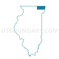
ANTIOCH 11 Voting District, Lake County, Illinois
About
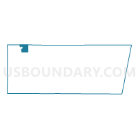
Outline

Summary
| Unique Area Identifier | 572310 |
| Name | ANTIOCH 11 Voting District |
| County | Lake County |
| State | Illinois |
| Area (square miles) | 10.72 |
| Land Area (square miles) | 10.25 |
| Water Area (square miles) | 0.47 |
| % of Land Area | 95.64 |
| % of Water Area | 4.36 |
| Latitude of the Internal Point | 42.46889420 |
| Longtitude of the Internal Point | -88.03405190 |
Maps

Graphs
Select a template below for downloading or customizing gragh for ANTIOCH 11 Voting District, Lake County, Illinois


Neighbors
Neighoring Voting District (by Name) Neighboring Voting District on the Map
- ANTIOCH 10 Voting District, Lake County, IL
- ANTIOCH 12 Voting District, Lake County, IL
- ANTIOCH 5 Voting District, Lake County, IL
- ANTIOCH 6 Voting District, Lake County, IL
- BRISTOL - T 5 Voting District, Kenosha County, WI
- BRISTOL - T 6 Voting District, Kenosha County, WI
- BRISTOL - T 7 Voting District, Kenosha County, WI
- LAKE VILLA 158 Voting District, Lake County, IL
- LAKE VILLA 159 Voting District, Lake County, IL
- LAKE VILLA 160 Voting District, Lake County, IL
- NEWPORT 230 Voting District, Lake County, IL
- NEWPORT 231 Voting District, Lake County, IL
- SALEM - T 11 Voting District, Kenosha County, WI
- SALEM - T 15 Voting District, Kenosha County, WI
Top 10 Neighboring County Subdivision (by Population) Neighboring County Subdivision on the Map
- Lake Villa township, Lake County, IL (40,276)
- Antioch township, Lake County, IL (27,745)
- Salem town, Kenosha County, WI (12,067)
- Newport township, Lake County, IL (6,770)
- Bristol town, Kenosha County, WI (2,330)
Top 10 Neighboring Place (by Population) Neighboring Place on the Map
- Antioch village, IL (14,430)
- Lake Villa village, IL (8,741)
- Lake Shangrila CDP, WI (861)
- Old Mill Creek village, IL (178)
Top 10 Neighboring Elementary School District (by Population) Neighboring Elementary School District on the Map
- Antioch Community Consolidated School District 34, IL (23,861)
- Salem School District, WI (9,270)
- Millburn Community Consolidated School District 24, IL (8,613)
- Bristol No. 1 School District, WI (4,960)
Top 10 Neighboring Secondary School District (by Population) Neighboring Secondary School District on the Map
- Warren Township High School District 121, IL (68,588)
- Antioch Community High School District 117, IL (45,037)
- Westosha Central High School District, WI (19,682)
Top 10 Neighboring State Legislative District Lower Chamber (by Population) Neighboring State Legislative District Lower Chamber on the Map
- State House District 61, IL (120,629)
- Assembly District 65, WI (61,608)
- Assembly District 66, WI (61,567)
Top 10 Neighboring State Legislative District Upper Chamber (by Population) Neighboring State Legislative District Upper Chamber on the Map
Top 10 Neighboring 111th Congressional District (by Population) Neighboring 111th Congressional District on the Map
Top 10 Neighboring Census Tract (by Population) Neighboring Census Tract on the Map
- Census Tract 8608.10, Lake County, IL (7,231)
- Census Tract 8660, Lake County, IL (6,785)
- Census Tract 27, Kenosha County, WI (5,517)
- Census Tract 8610.12, Lake County, IL (5,076)
- Census Tract 29.06, Kenosha County, WI (4,884)
- Census Tract 8610.07, Lake County, IL (4,370)
- Census Tract 8608.11, Lake County, IL (4,169)
Top 10 Neighboring 5-Digit ZIP Code Tabulation Area (by Population) Neighboring 5-Digit ZIP Code Tabulation Area on the Map
- 60046, IL (35,111)
- 53142, WI (32,375)
- 60002, IL (24,299)
- 60083, IL (9,838)
- 53179, WI (6,310)
- 53104, WI (5,426)